


Citilabs Adds Pedestrian Data To Massive U.S. Dataset On Population Movement
May 1, 2018 by Dave Haynes
Sacramento-based mobility analytics solution provider Citilabs has added another interesting layer of mass data to a platform that shows the movement of people in the U.S. The company has added pedestrian data on top of traffic data.
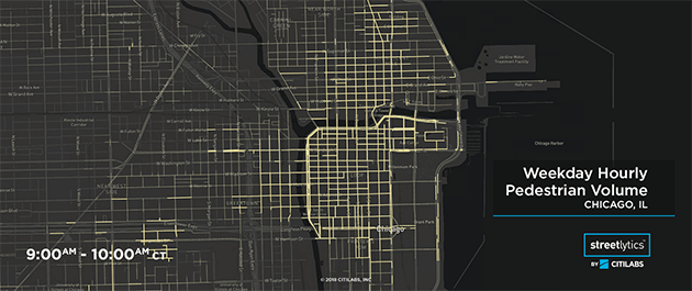
Streetlytics now includes the first-of-its-kind pedestrian analytics dataset – using billions of data points to measure and paint a complete picture of the moving population, hour-by-hour. The data includes origin-destination movements, all streets directional road volumes for vehicles and pedestrians, and traveler demographics based on derived home locations.
The location data comes from companies that sell what’s collected from smart phones, in-vehicle probes and other similar devices.
This data is relevant, in the context of signage, for things like planning digital out of home billboard and poster locations, as well as campaigns on those signs.
In a broader sense, the data is useful for city planners who are increasingly challenged to develop city designs that consider people traveling by not only vehicles, but also walking and biking. Retailers can understand who is walking in front of their stores, real estate professionals can understand where to develop, and autonomous vehicles can be better prepared for pedestrian traffic.
“Streetlytics provides a comprehensive understanding of population movement – and that understanding now includes pedestrians,” says Citilabs CEO Michael Clarke. “We are excited to make this new data available for the first time to our clients and partners. It will be key to designing and optimizing the transportation solutions and cities of tomorrow.”
I did a podcast chat a few months ago with Clarke, to talk about how this all works, as well as its applications.
Leave a comment